
Water in Bradford Beck is cleaner than it has been for many years though pollution can still occur.
More work needs to be done to bring back lost wildlife to a recreated water environment that restores natural conditions and is an asset to the city of Bradford.
Action through the European Water Framework Directive is one way this can happen.
A new deal for water: the Water Framework Directive
This website you are reading supports a Europe-wide movement of like minded people working to improve their water environment.
The Water Framework Directive (WFD) which came in to force in December 2000, is the latest in a long line of legislation dating back to medieval times to protect and improve our rivers and streams.
From a low point in the late 19th Century, the quality of Yorkshire’s rivers has seen a slow but steady improvement. Prompted initially by concerns over public health, successive waves of legislation and improved infrastructure has meant our water courses are now cleaner than they have been since before the industrial revolution. Changes in our economy too have played their part with the disappearance of the most polluting industries.
Traditionally assessing the condition of our rivers was a job for chemists. Decades of monitoring chemical water quality has brought to end many harmful discharges. But today we expect more from our rivers than a flow of chemically clean water.
We want to see rivers of life, a home to aquatic creatures great and small and natural waterside vegetation. We want to see an attractive river channel resembling a pre-industrial ideal, before the innate behaviour of flowing water was constrained in a straight jacket of culverts, weirs, dams and brick and concrete channels.
There were good reasons why we engineered our watercourses. Weirs and water mills provided power, bridges were needed for a growing transport network, dam walls captured drinking water to satisfy our thirst and culverting allowed the growth of cities and towns. Many of these reasons are still relevant to our lives, as increasingly is the need to prevent flooding. But sometimes engineering no longer serves any purpose. The Water Framework Directive asks that where possible it should now be removed. Where structures must remain, the Directive urges us to look for ways of reducing its impact, such as building fish passes on weirs.
Apart from being better for wildlife and people, more natural watercourses are less likely to lead to damaging floods.
But who should say how we manage our rivers and streams?
Farmers, developers, industrialists, water companies, anglers, conservationists and local residents (to name but a few), all have their own needs and priorities for water.
To resolve this conundrum the WFD proposes the catchment based approach, creating a voluntary forum of interested parties to discuss, debate, plan and improve the water environment. Bradford Beck has its own group to care for it but is also of interest to the over-arching Aire and Calder Catchment partnership http://www.aireandcalderpartnership.org/
In this partnership statutory bodies and voluntary groups work together to plan and promote environmental improvements on and around the rivers and streams of the Aire and Calder.
Bradford Beck: the WFD opportunities
It is the job of the Environment Agency to monitor the waters of Bradford Beck and classify them each year against a set of Water Framework Directive (WFD) standards. Where those standards aren’t being achieved action is needed. WFD sets a date of 2027 for these standards to be met. Action by the Friends of Bradford Beck is one way these improvements can be made.
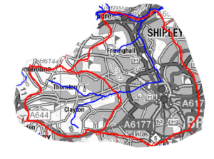
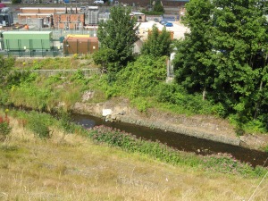
The Environment Agency has divided Bradford Beck to two parts. An upper rural portion known as Clayton Beck and a downstream urban section through the city centre. The boundary is on Cemetery Road, Lidget Green.
Clayton Beck
Monitoring is carried out for 15 different parameters on Clayton Beck and 12 of these were meeting the WFD objective in 2015. The numbers of aquatic invertebrates and plants were not what would be expected however. Also there was too much phosphate, a chemical linked with sewage or agricultural run-off. There is a high weir off Glenbrook Drive which would limit the movement of fish.
City Centre
The Environment Agency measures 15 parameters in this section of the beck and 13 of them (including fish) were meeting the WFD standard (2015). Again the aquatic invertebrate population is relatively poor, probably due to the in-stream habitat as chemically the water in the beck complies with all WFD standards. The main WFD opportunities along this part of the beck are reversing or at least ‘softening’ historical physical alterations.
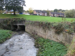
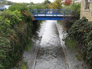
Below Cemetery Road the nature of the Beck changes. There are weirs off Princeville Road which would be a barrier to the movement of fish. The beck lies in a deep, narrow, fast-flowing artificial channel, which is a poor habitat for wildlife. Then it is lost underground beneath the city centre, though pavement plaques laid by Friends of Bradford Beck show its course. Along Canal Road the beck flows through a sterile U-shaped, brick lined channel but beyond Poplar Road it lies in a semi-natural bed. There is great potential here for habitat improvements and a public open space. Before the confluence with the Aire near Shipley station, there is a weir used to measure the flow of water which could also restrict the movement of fish.
The environmental improvements which have taken place along Bradford Beck have been hard won. Through the work of Friends of Bradford Beck we hope this process will continue. But there is no room for complacency; pollution or inappropriate development can harm the beck and also set back its status under WFD.
Any pollution of Bradford Beck can be reported to the Environment Agency 24 hour incident hotline 0800 80 70 60
